School Colindale  Park Colindale P P P McDonald’s Drive-thru National Blood Transfusion Centre NW London Health Protection Unit Elysian House The Technology Park Montrose Recreation Ground Allotments Silk Stream Silk Stream Allotments Sports Ground MONTROSE AVE HOLMSTALL AVE THE                                   GREENWAY SOUTHBOURNE            AVE GREENWAY       GDNS CARLISLE RD       GROVE  PARK  EVELYN                       AVE ROSE    GLEN ST. GEORGE’S AVE GROVE CRESC   COLIN        PARK                      RD  MANOR         WAY COURT                       WAY AJAX         AVE PLAZA WALK AIRCO CL WESTFIELD  CL CECIL RD BOOTH RD AEROVILLE PASTEUR CL LISTER CT CURIE GDNS FLEMING WALK CHEQUERS  CL STONECROP CL CRANESBILL CL ORCHARD GATE BEAULIEU CL GREENWAY CL PORTMAN GDNS FALCON WAY WINDOVER         AVE School Stores Asda Morrisons Merit House Post Office Grove Park Industrial Estate Capitol Industrial Park Colindale Business Park H&R H&R Morrisons Merit House Colindale Business Park National Blood Transfusion Centre NW London Health Protection Unit Elysian House CHARCOT JOSLIN AVE LINGARD  AVE MORNINGTON  CL Rhythm Rhythm Pulse Pulse GUARDIAN     AVE RD 100m 200m 300m 400m 500m Point at Info tags for more information and click on bus route or station labels for time table information For a larger scale view and zoom facilities please  click on this link for the same map in pdf format
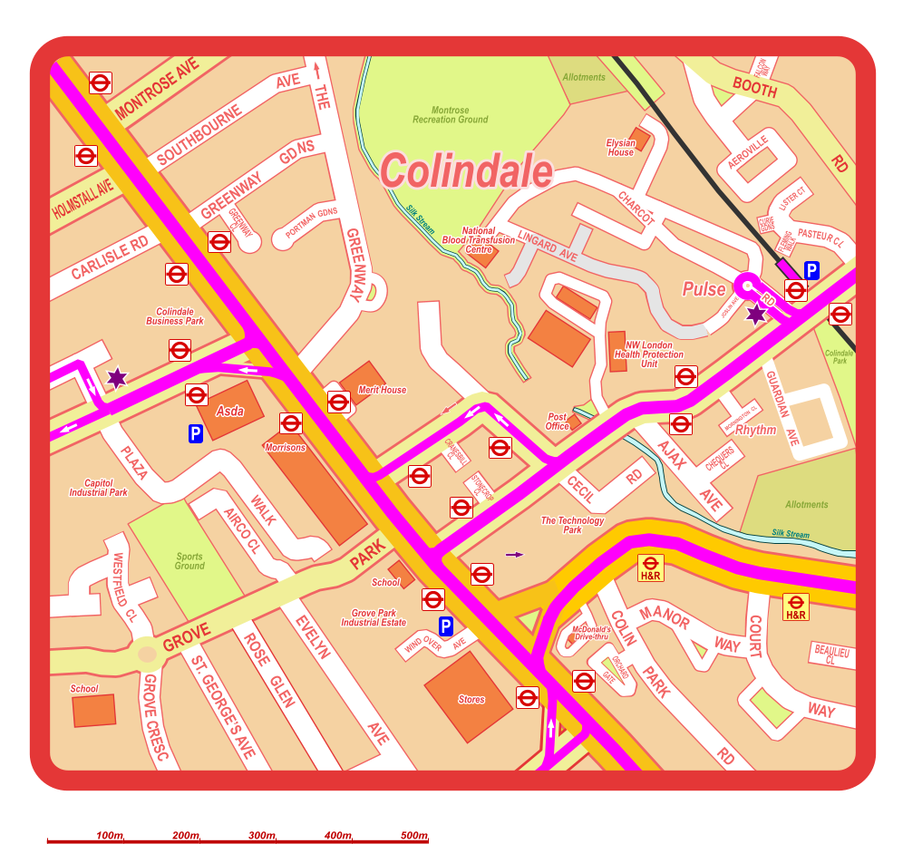
Map of Colindale Area with Transport Connections
pdf Area Transport Maps Custom Maps Other Transport Maps LONDON LOCAL AREAS PUBLIC TRANSPORT MAPS www.londonlocalmaps.com Northern Line Edgware Branch Colindale Station, Northern Line bus 292  N 303 292 bus 32 bus 142 bus 303 bus N16 32 142 292 N16 32 142 N16 324 204 N5 32 142 N16 N5 324 204 bus 204 303 303 bus N5 324 204 303 N5 bus 324 632 642 632 642 ©2010-2023 Michael Strauss. Map contains Ordnance Survey data ©Crown copyright and database right 2011-2023 LONDON LOCAL AREAS PUBLIC TRANSPORT MAPS www.londonlocalmaps.com Map of Public Transport Connections in the Colindale Area (click on bus route numbers / train or underground line labels for timetable information)s EDGWARE EDGWARE RD RD HAY  LA LA COLINDEEP AVE ANNESLEY COLINDALE AVE CAPITOL       WAY CAPITOL WAY 204 303 N5 125 125 303 info  info  info info info  legend For a complete map of bus & coach routes and underground & train lines for the whole Borough of Barnet and neighbouring areas click here info
One Way P Car Park TAXI MINI CAB Taxi Rank Mini Cab Office Cyclepath B Road Other Principal Road Footpath A Road Restricted Access Regular Service (except late night) 184 383 N20 134 610 24 hour Service Limited Service Night Service Bus/Coach Services (non TfL) 702 Key Underground Station Rail Station Overground Station Bus/Coach Stop Bus Route (TfL) Route Terminus 84 Bus Route (non TfL) H&R Hail & Ride Section
 Grahame Park, Burnt Oak, Edgware Station 303 632 642 N5 204 Grahame Park, Mill Hill, Edgware Station Grahame Park Corner Mead Grahame Park, Mill Hill, Edgware, Stanmore London Academy Grahame Park, Burnt Oak, Edgware Station 125 Hendon, Finchley, Whetstone, Southgate, Winchmore Hill
 Hendon, Brent Cross Shopping Centre, North Cricklewood Tesco 324
 West Hendon, Brent Cross Shopping Centre West Hendon, Cricklewood,  Kilburn, Kilburn Park Station Cricklewood, Kilburn, Maida Vale, Marble Arch, Victoria Station N16 32 142 632 642 West Hendon, Cricklewood,  Kilburn, Kilburn Park Station West Hendon Herbert Road N5 Hendon, Golders Green, Hampstead,  Camden Town, Trafalgar Square
 Kingsbury, Preston Road, Wembley, Sudbury Town Station 324 Kingsbury, Queensbury, Stanmore, Elstree Centennial Park 204
 Burnt Oak, Edgware Station N16 32 142 Edgware, Stanmore, Bushey, Watford Junction Station 292 Edgware, Mill Hill, Elstree, Borehamwood Rossington Avenue Burnt Oak, Edgware Station
 Roe Green, Kingsbury 303