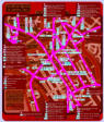
List of London Areas Transport Maps
All London Bus, Undeground, Train, DLR, Tram, Coach
and River Bus lines and routes and connections
with stations, stops, destination and timetable information,
also showing many Cycle Hire docking stations

For best quality zoom-in results
and name search facilities please
use the pdf files, best viewed
with Adobe Reader.


comprehensive public transport maps for London communities
local area bus route maps
www.londonlocalmaps.com


Greenwich

Camden

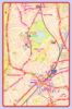
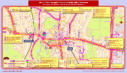
Bow Area
Map includes Bow, Old Ford, Hackney Wick, Stratford,
Leyton, Buses from/to Stratford Station, The Olympic
Park, Bow Church, Stratford International Station


Putney High Street & Putney Bridge
Station Areas
Map includes Fulham High Street, Parsons Green,
Hurlingham, Buses from/to Putney Bridge Station,
Putney Station, Putney East Station, Putney Pier


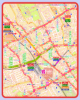
Islington

Islington (Angel & Highbury Corner Areas)
Map includes Barnsbury, Lower Holloway, Upper Street,
Business Design Centre, Buses from/to Angel Station,
Highbury & Islington Station, Essex Road Station

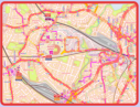
Stratford Area


Canning Town, ExCeL London & London
City Airport Areas
Map includes Silvertown, North Woolwich, West
Beckton, Prince Regent, Buses from/to Canning Town
Station, ExCeL & ICC London, London City Airport


Wimbledon & Wimbledon Park Areas
Map includes Southfields, South Wimbledon, The
Wimbledon All England Lawn Tennis & Croquet Club,
Buses from/to Wimbledon Station, Tennis Special Buses


Map includes Bow, Old Ford, Hackney Wick, Stratford,
Leyton, Buses from/to Stratford Station, The Olympic
Park, Bow Church, Stratford International Station


Haringey
Wood Green & Turnpike Lane Areas
Map includes West Green, Hornsey, Noel Park, Wood
Green Shopping City, Buses from/to Wood Green
Station, Turnpike Lane Station

Hammersmith & Fulham
Hammersmith Bus & Underground
Stations Area
Map includes Barons Court, King’s Mall, Hammersmith
Apollo, Buses and Coaches from/to Hammersmith Bus
Station and Hammersmith Underground Stations

Hackney
Hackney Wick Area


Fulham High Street & Putney Bridge
Station Areas
Map includes Putney High Street, Parsons Green,
Hurlingham, Buses from/to Putney Bridge Station,
Putney Station, Putney East Station, Putney Pier


Map includes Bow, Old Ford, Hackney Wick, Stratford,
Leyton, Buses from/to Stratford Station, The Olympic
Park, Bow Church, Stratford International Station


Enfield
Enfield Town Area
Map includes Enfield Chase, Enfield Trading Estate,
Bush Hill Park, Buses from/to Enfield Town Station,
Enfield Chase Station

North Acton & Park Royal Areas
Map includes Harlesden, West Acton, North Ealing,
Stonebridge Park, Buses from/to North Acton Station,
Park Royal, Central Middlesex Hospital

Ealing


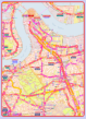
Greenwich, North Greenwich &
Blackheath Areas
Map includes Cubitt Town, Blackheath Village, Charlton,
Lewisham, Buses from/to North Greenwich Station,
The O2, Lewisham Station, Greenwich Park, Cutty Sark


Aldgate, Spitalfields & Tower Hill Areas
Map includes Broadgate, Bishopsgate, Tower Bridge,
St. Katharine’s, Buses from/to Liverpool Street Station,
Fenchurch Street Station, Aldgate Station


City of London


Woolwich, North Woolwich & Queen
Elizabeth Hospital Areas
Map includes Woolwich Arsenal, Plumstead Common,
Royal Artillery Barracks, Buses from/to Woolwich
Arsenal Station, Queen Elizabeth Hospital


Park Royal & North Acton Areas
Park Royal & North Acton Areas
Larger scale map featuring more details of bus routes
serving Central Middlesex Hospital and North Acton Station
Map includes Buses from/to Central Middlesex Hospital,
North Acton Station, Park Royal

Brent


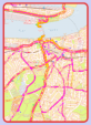
The Royal Free Hospital Hampstead
Map includes Hampsted Heath Station, Belzise Park
Station, Buses from Hampstead Heath Station, Royal
Free Hospital
Live Music Venues in Camden Town
(featuring show, event & transport information)
Map includes Koko, Dingwalls, Roundhouse, Jazz Cafe,
Underworld, Electric Ballroom, Buses from/to Camden
Town & Camden Road Stations, Chalk Farm Station
Camden Town Area
Map includes Chalk Farm, Primrose Hill, Regent’s Park,
Camden Lock, Buses from/to Camden Town Station,
Camden Road Station, Chalk Farm Station


Map includes Harlesden, West Acton, North Ealing,
Stonebridge Park, Buses from/to North Acton Station,
Willesden Junction Station, Central Middlesex Hospital


High Barnet & New Barnet Stations Area
Map includes Underhill, East Barnet, Barnet Vale,
Lyonsdown, Buses from/to High Barnet Station, New
Barnet Station
Brent Cross & Hendon Central Area
Map includes Brent Cross Shopping Centre, North
Cricklewood, West Hendon, Buses & Coaches from/to
Brent Cross Shopping Centre, Hendon Central Station
Colindale Area
Map includes Oriental City, Elysian House, Silkstream
Unit, National Blood Service, Buses from/to Colindale
Station, The Hyde
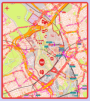
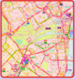
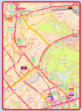
Barnet Borough Area
also including Borehamwood, Cricklewood,
Hampstead, Highgate, Kingsbury, Queensbury,
Wembley Park, Muswell Hill, Neasden
High resolution map
pdf format only
Slow download
Edgware Area
Map includes Burnt Oak, Stone Grove, Mill Hill,
Edgware Bury, Buses from/to Edgware Station, Burnt
Oak Station, Edgware Community Hospital


Barnet
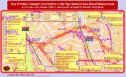


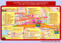
Click on the html button for the map with many dynamic content features.
Maps marked “Individual Bus Routes” allow for each bus route to be
highlighted individually and also seperately for each direction.
Click on the pdf button for the same map if you want to zoom in for the smallest
details without loss of quality. The PDF maps are designed to work best with
the latest version of the Adobe Reader, which will also allow for searching for
specific street and place names using the Adobe Reader “Find” function.
Download the latest Adobe Reader here


Wembley & Wembley Park Areas
Map includes Brent Park, Neasden, Buses from/to
Wembley Central, Park & Stadium Stations, Wembley
Arena & Stadium, Brent Town Hall


Kensington & Chelsea

Earl’s Court, West Kensington
& High Street Kensington
Map includes West Brompton, Barons Court, The
Queen’s Club, Kensington Olympia. Buses from/to
Earl’s Court, Kensington High Street & Olympia


St. John’s Wood, Lisson Grove & Swiss
Cottage Areas, Baker Street & Marylebone Stations
Map includes Primrose Hill, Regent’s Park, London Zoo,
Buses from/to Baker Street and Marylebone Stations,
Lord’s Cricket Ground, Madame Tussaud’s


Westminster, St. James’s, Belgravia
& Mayfair Areas
Charing Cross, Victoria & Victoria Coach Stations
Map includes Piccadilly, Buckingham Palace, Parliament
Buses from/to Charing Cross, Victoria & Victoria Coach
Stations, Leicester Square, Westminster Abbey


Knightsbridge, South Kensington, Chelsea
& Hyde Park
Map includes Brompton, The Victoria & Albert, Science
& Natural History Museums, Royal Albert Hall. Buses
from/to Hyde Park, South Kensington Museums


Kingston (Town Centre) & Surbiton Areas
Map includes Kingston Bus Stations, Shopping Centres,
University Sites, Long Diton,Thames Ditton, Buses
from/to Kingston Train/Bus Stations, Surbiton Station


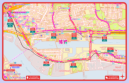
Hampton Court & Teddington Areas
Map includes Hampton Court & Teddington Stations,
Hampton Court Palace, Hampton Wick, Bushy Park,
Buses from/to Hampton Court, Teddington


Low resolution map
pdf format only
Faster download

If there is a
Browser
message “server
not responding”
please ignore


Bermondsey & Old Kent Road Areas
Map includes London Bridge & Bermondsey Stations,
Guy’s Hospital, parts of Peckham, The Borough,
Walworth, Buses from/to Bermondsey, Old Kent Road


Harringay, Hornsey & Finsbury Park Areas
Map includes Crouch End, Hornsey Vale, Stroud Green,
Upper Holloway, Buses from/to Finsbury Park Station,
Harringay & Harringay Green Lanes Stations


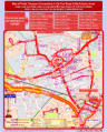
Bank, St. Paul’s & Blackfriars Areas
Map includes Barbican, Moorgate, Tate Modern,
Smithfields, Buses from/to Blackfriars, Moorgate,
Cannon Street & Blackfriars Stations