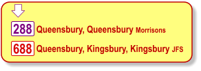
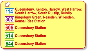
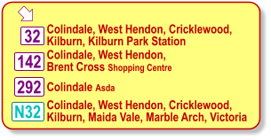
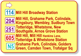
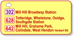
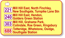
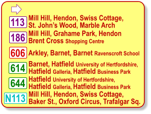
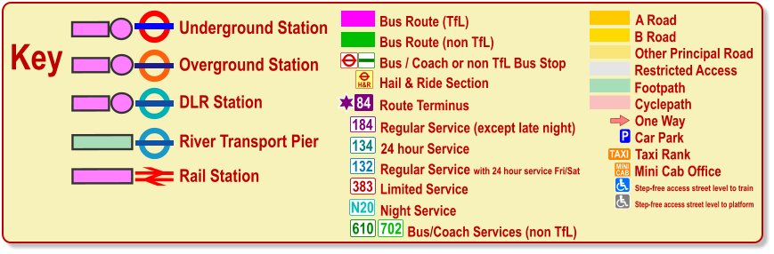
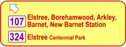
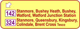
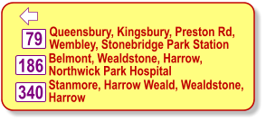
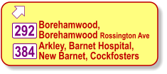
Point at Info tags for more information and click on bus route or station labels for time table information For a larger scale view and zoom facilities please  click on this link for the same map in pdf format
Map of Edgware Area with Transport Connections
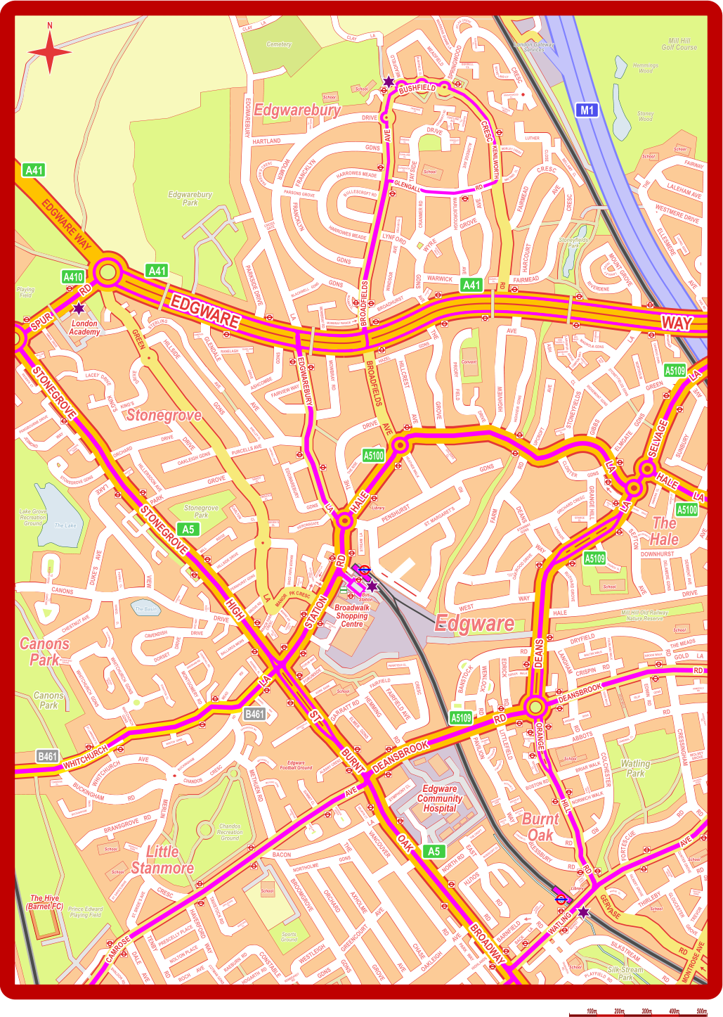
LONDON LOCAL AREAS PUBLIC TRANSPORT MAPS www.londonlocalmaps.com Other Transport Maps Custom Maps Area Transport Maps pdf MONTROSE AVE EDGWARE WAY PLAYFIELD  RD ROCH      AVE COTMAN GDNS SHALDON RD PANGBOURNE DRIVE FAIRWAY THE THE MEADS MILL CL CARLTON HERONSGATE QUEEN’S  CL OLD RECTORY  GDNS FORUM WAY PRINCES  CL SAVOY  CL PARKFIELD CL ELMER   GDNS EDRICK WALK APPROACH  RD RIDGE MANNS RD GARDEN  CITY CHILTON  RD PEACHY  CL HORN  BANK THE CROFT ROSSCOFF CL BACK       LA MARKET  LA RIVER  APPROACH STREAM  LA THE RISE GOLDERS  CL HAZEL GDNS BELLAMY   CL MAYTREE   CL       MORLEY CRESC CROMARTY RD KNIGHTSWOOD CL FULBECK WALK       BOYSELAND CT           ATLAS CRESC BURRELL CL RUSHMEAD CL    WARRENS SHAWE LA BUSHFIELD  CL CLAY CLAY LA LA HAMONDE CL KINROSS CL PENTLAND AVE RANNOCH CL MORAY CL KINGSLEY CT DUNBLANE CL GLENDEVON CL BEULAH CL ROSEN’S WALK PARNELL CL HURSTMEAD CT MOWBRAY RD MOWBRAY PARADE WOLMER CL         PARSON’S CRESC HARTLAND CL COMPASS CL AVE STERLING RANELAGH DRIVE RANELAGH CL SHELLEY CL CAMPBELL CROFT WILLOW CT CAMPION  WAY LARKSPUR GROVE FIRE- THORN CL IRIS WALK SYCAMORE CL HIBISCUS CL ROSE WAY BERBERRY CL NORTHOLM OAKMEAD GDNS BRIARDALE BOXELDER CL GRENVILLE PL HAWKINS  CL HALE CL DEANS      DRIVE GRANGE CL BELGRAVE CL CHURCH  CL MEADOW GDNS FOURLAND WALK WALTER WALK BROOK WALK HOOK WALK ISLIP GDNS DEAN WALK LANGHAM             GDNS CARDINAL  CL BERNHART CL RUDDOCK CL KIRTON WALK TRUMAN CL HUTTON ROW COMPTON CL BOTHAM CL BREARLEY CL GATTING CL BRADMAN ROW GRACE CL LYNFORD CL PARK CROFT NURSE   CL HANSHAW DRIVE TREVOR GDNS ARUNDEL GDNS WOLSEY GROVE HORSECROFT RD HOMEFIELD RD ST. DAVID’S DRIVE NEWGALE GDNS APPLEDORE CL BIDEFORD CL SUMMIT CL SELWYN CT ALBANY CRESC BERRIDGE GREEN PENYLAN PL PEMBROKE PL MILFORD GDNS METHUEN CL OVERBROOK WK HANDEL               WAY SPRINGVILLA RD WINTON  GDNS BUCKINGHAM GDNS TORBRIDGE CL ST. LAWRENCE CL STRATTON  CL QUEENS MEAD WHITCHURCH CL WOODSTEAD GROVE CHURCHILL RD GRESHAM RD RODWELL  PL RYE WAY CANONS CL LODGE CL HANDEL          CL POWELL   CL ORCHARD CL ROSE GARDEN CL REGENTS  CT CALTHORPE GDNS MAYFAIR CT LAUREL GDNS PIKE  RD     LANGLEY  CRESC London Gateway Services Mill Hill Golf Course Hemmings Wood Stoney Wood PARK   WAY HIGHLANDS GASKARTH  RD 100m 200m 300m 400m 500m  N AMIAS  DRIVE GLENGALL RD Edgwarebury Edgware Burnt Oak The Hale Little Stanmore Canons Park Edgware Community Hospital Broadwalk Shopping Centre Bus Station Edgware Football Ground School School School School School School School School Library School School School School School School School Convent Library Watling Park Mill Hill Old Railway Nature Reserve Stoneyfields Park Edgwarebury Park Cemetery Canons Park Lake Grove Recreation Ground Stonegrove Park  Playing Field Prince Edward Playing Field Chandos Recreation Ground Sports Ground The Lake The Basin Silk Stream Park EDGWARE EDGWARE WAY WAY STONEGROVE STONEGROVE STONEGROVE STONEGROVE HIGH HIGH ST ST BURNT BURNT OAK OAK BROADWAY BROADWAY WHITCHURCH WHITCHURCH LA LA STATION STATION RD RD HALE HALE LA LA HALE HALE LA LA LA LA SELVAGE SELVAGE RD RD SPUR SPUR LA LA DEANS DEANS DEANSBROOK DEANSBROOK RD RD RD RD DEANSBROOK DEANSBROOK AVE AVE WATLING WATLING AVE AVE CAMROSE CAMROSE RD RD HILL HILL ORANGE ORANGE LA LA EDGWAREBURY EDGWAREBURY BROADFIELDS BROADFIELDS AVE AVE CRESC CRESC BUSHFIELD BUSHFIELD KENILWORTH KENILWORTH GLENGALL RD Edgwarebury Edgware Burnt Oak The Hale Little Stanmore Canons Park Edgware Community Hospital Broadwalk Shopping Centre Bus Station Edgware Football Ground School School School School School School School School Library School School School School School School School Convent Library Watling Park Mill Hill Old Railway Nature Reserve Stoneyfields Park Edgwarebury Park Cemetery Canons Park Lake Grove Recreation Ground Stonegrove Park  Playing Field Prince Edward Playing Field Chandos Recreation Ground Sports Ground The Lake The Basin Silk Stream Park Stonegrove Stonegrove  London Academy  London Academy The Hive (Barnet FC) Map of Edgware, Public Transport Edgware, Buses Edgware, Edgware Station, Burnt Oak Station, Edgware Community Hospital N113 N113 N113 644 614 644 614 644 614 642 614 644 614 384 384 384 N113 644 614 384 384 N113 N32 644 614 N32 644 614 N32 644 N32 N32 LONDON LOCAL AREAS PUBLIC TRANSPORT MAPS www.londonlocalmaps.com ©2010-2023 Michael Strauss. Map contains Ordnance Survey data ©Crown copyright and database right 2011-2023 info  info info legend info  info  info info info info info info For a complete map of bus & coach routes and underground & train lines for the whole Borough of Barnet and neighbouring areas click here
Updated August 2023
 Queensbury, Queensbury Morrisons Queensbury, Kingsbury, Kingsbury JFS 288 688
606  Queensbury, Kenton, Harrow, West Harrow, South Harrow, South Ruislip, Ruislip 114 Kingsbury Green, Neasden, Willesden, Kensal Rise Station  Queensbury Station 302 Queensbury Station 644 614 Queensbury Station
 Colindale, West Hendon, Cricklewood, Kilburn, Kilburn Park Station 142 32 Colindale Asda N32 292 Colindale, West Hendon, Brent Cross Shopping Centre Colindale, West Hendon, Cricklewood, Kilburn, Maida Vale, Marble Arch, Victoria
 Mill Hill Broadway Station 204 N5 Mill Hill, Grahame Park, Colindale, Kingsbury, Wembley, Sudbury Town    114 605 Totteridge, Whetstone, New Southgate, Arnos Grove Station  Mill Hill, Mill Hill Hankins Lane, Totteridge & Whetstone Station    251 Grahame Park, Colindale, Golders Green, Camden Town, Trafalgar Sq
628  Mill Hill Broadway Station 302 642 Totteridge, Whetstone, Osidge, Southgate Station  Mill Hill, Grahame Park, Colindale, West Hendon Herbert Rd
 Mill Hill East, North Finchley, New Southgate, Turnpike Lane Stn 240 Mill Hill East, Hendon, Golders Green Station Totteridge, Whetstone, Osidge, Southgate Station  221 688 303 Mill Hill, Grahame Park, Colindale, Roe Green, Kingsbury
606  Mill Hill, Hendon, Swiss Cottage, St. John’s Wood, Marble Arch 186 Arkley, Barnet, Barnet Ravenscroft School Mill Hill, Grahame Park, Hendon Brent Cross Shopping Centre Barnet, Hatfield University of Hertfordshire, Hatfield Galleria, Hatfield Business Park 113 N113 Mill Hill, Hendon, Swiss Cottage, Baker St., Oxford Circus, Trafalgar Sq. 644 614 Hatfield University of Hertfordshire, Hatfield Galleria, Hatfield Business Park
One Way P Car Park TAXI MINI CAB Taxi Rank Mini Cab Office Cyclepath B Road Other Principal Road Footpath A Road Restricted Access Bus / Coach or non TfL Bus Stop Bus Route (TfL) Route Terminus 84 Bus Route (non TfL) H&R Hail & Ride Section Regular Service (except late night) 184 383 N20 134 610 24 hour Service Limited Service Night Service Bus/Coach Services (non TfL) 702 Key Underground Station Rail Station Overground Station DLR Station River Transport Pier Olympic Venue Paralympic Venue Step-free access street level to train Step-free access street level to platform 132 Regular Service with 24 hour service Fri/Sat
 Elstree, Borehamwood, Arkley, Barnet, New Barnet Station 107 Elstree Centennial Park 324
 Stanmore, Bushey Heath, Bushey, Watford, Watford Junction Station 142 Stanmore, Queensbury, Kingsbury,  Colindale, Brent Cross Tesco 324
 Queensbury, Kingsbury, Preston Rd, Wembley, Stonebridge Park Station 186 79 340 Belmont, Wealdstone, Harrow, Northwick Park Hospital Stanmore, Harrow Weald, Wealdstone,  Harrow
 Borehamwood,  Borehamwood Rossington Ave  292 384 Arkley, Barnet Hospital, New Barnet, Cockfosters